
Epoxy
February 19, 2021
Great Summary of Where We Are–It’s Going to be a Rough Few Weeks
U.S. Gulf Coast storm outages rise, send ripples round global markets; Area plant status list update included
by WILL BEACHAM, Deputy Editor, ICIS Chemical Business
February 19, 2021
The US polar storm has now shut down 90% of US polypropylene (PP) capacity, 67% of ethylene and devastated other important products, sending ripples around global chemical markets prices soaring.
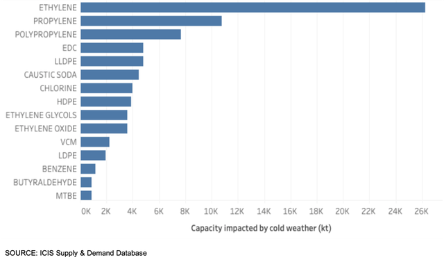
More chemical plants and refineries across the Gulf Coast region have been hit by prolonged power and feedstock outages caused by freezing weather, snow and ice which have also halted logistics networks. More bad weather, forecast for later in the week, may prolong the disruption.
So far, ICIS has reported more than 60 plant outages as a result of the storm, with analysis using data from the ICIS Supply & Demand database showing that a wide swathe of the Gulf petrochemical sector has now been severely impacted.
Worst hit in volume terms is ethylene, with 26m tonnes of capacity offline, representing 67% of the US total. Around 11m tonnes, or 50%, of propylene capacity is also offline, with many of the region’s oil refineries also seeing curtailed production. More than 2m bbl/day of US oil refining capacity is shut down.
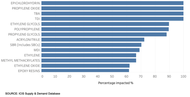
In percentage terms, the major commodities worst affected are epichlorohydrin (ECH) (100% of US capacity offline), propylene oxide (PO) (100%), toluene diisocyanate (TDI) (100%), ethylene glycol (EG) (90%), polypropylene (PP) (90%), propylene glycol (88%), acrylonitrile (ACN) (73%) and styrene butadiene rubber (SBR) (71%).
The outages are tightening global markets which were already suffering shortages of material and rising prices. Problems with the global container shipping system, plant outages plus healthy downstream demand have caused tightness, notably down the propylene and polyethylene (PE) chains.
Propylene and PP are likely to be one of the hardest-hit by the storms because the market was already in turmoil. The coronavirus pandemic has reduced demand for transport fuels, and led to oil refineries closing or cutting production, particularly in Europe and the US.
These closures had a knock-on effect on the supply of propylene and PP, leading to price spikes. With US PP production capacity so highly concentrated on the Gulf Coast, even temporarily constrained production capabilities will have a massive effect on an already tightly supplied market.
US propylene prices are at 10-year highs and inventories are roughly half of what they were a year ago. Consumption has outpaced production due to reduced propylene production over the last year.
PP inventories in the US hit seven-year lows in late 2020, partially driven by rebounding demand and partially driven by limited monomer availability. Some PP production issues also preceded this weather event.
The situation is less dramatic in PE. Constrained supply and demand for packaging has sustained global markets through the pandemic, with logistics challenges and outages causing shortages and price spikes in 2021.
With almost two thirds of US ethylene capacity now offline, global PE markets are likely to tighten further.
US methyl methacrylate (MMA) supply is also expected to be further constrained thanks to the storm, as Lucite has taken down its plant in Beaumont, Texas. Severe constraints in feedstock acetone continue to limit production. Due to high costs, a producer is heard to be levying a temporary acetone surcharge on orders starting this month.Expand
With the Chinese New Year holidays coming to an end from 17 February, demand is picking back up in the world’s largest chemicals market. ICIS reported today that a supply shortage and improving demand after the holidays, supported China’s polyolefins market, leading to a surge in futures and spot prices.
Futures prices in China also rose sharply for styrene, mono ethylene glycol (MEG), polyester and polypropylene.
Prior to the holiday, domestic petrochemical trading had been robust accompanied by sharp price increases as market players anticipated strong post-holiday demand. Surging oil prices provided additional impetus for the uptrend.
In Africa, PE and PP sellers, from all origins, have withdrawn their offers in anticipation of disruption to US exports and a strong return post-holiday market.
Asia’s monoethylene glycol (MEG) prices surged on Thursday by 11% – the biggest daily gain on record – underpinned by tightening global supply, as the Chinese markets re-opened after a week-long holiday.
There are fears that US exports to Asia of key commodities such as ethylene could be disrupted by the storm-related outages.
Europe prices have also been buoyed by the storms. Rising upstream prices and bullish sentiment sent benzene prices up, and styrene prices are now at highs not seen since April 2018.Expand
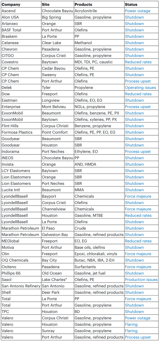
Area plant status
Additional reporting by: Lucy Shuai, Pearl Bantillo, Ben Lake, Judith Wang, Felicia Loo, Nurluqman Suratman, Amanda Hay, Tom Brown, Yashas Mudumbai, Helena Strathearn and Tarun Raizada,
https://www.bicmagazine.com/departments/operations/us-gulf-coast-storm-outages-rise-send-ripples/
February 19, 2021
Too Funny . . . What Did Farmers’ Almanac Predict?
U.S. Winter Outlook: Cooler North, warmer South with ongoing La Nina
Persistent drought dominates the Western landscape WeatherClimateclimate outlookswinter
October 15, 2020

NOAA’s winter forecast for the U.S. favors warmer, drier conditions across the southern tier of the U.S., and cooler, wetter conditions in the North, thanks in part to an ongoing La Nina. Forecasters at NOAA’s Climate Prediction Center — a division of the National Weather Service — are also closely monitoring persistent drought during the winter months ahead, with more than 45% of the continental U.S. now experiencing drought.
“NOAA’s timely and accurate seasonal outlooks and short-term forecasts are the result of improved satellite observations, more detailed computer forecast modeling, and expanding supercomputing capacity,” said Neil Jacobs, Ph.D., acting NOAA administrator. “From expansive and multi-hazard winter storms to narrow but intense lake effect snow, NOAA will provide the necessary information to keep communities safe.”
Currently, large areas of drought extend over the western half of the U.S., with parts of the Northeast also experiencing drought and near-record low stream flows. With a La Nina climate pattern in place, southern parts of the U.S. may experience expanded and intensifying drought during the winter months ahead.
“With La Nina well established and expected to persist through the upcoming 2020 winter season, we anticipate the typical, cooler, wetter North, and warmer, drier South, as the most likely outcome of winter weather that the U.S. will experience this year,” said Mike Halpert, deputy director of NOAA’s Climate Prediction Center.

This U.S. Winter Outlook 2020-2021 map for temperature shows above-average temperatures are likely in the South and below-average temperatures likely in parts of the North. (NOAA Climate.gov, using NWS CPC data)
Temperature
The greatest chances for warmer-than-normal conditions extend across the Southern tier of the U.S. from the Southwest, across the Gulf states and into the Southeast. More modest probabilities for warmer temperatures are forecast in the southern parts of the west coast, and from the Mid-Atlantic into the Northeast. Above-average temperatures are also favored for Hawaii and western and northern Alaska.
Below-normal temperatures are favored in southern Alaska and from the northern Pacific Northwest into the Northern Plains, with equal chances for below-, near- or above-average temperatures in the remaining regions.

This 2020-2021 U.S. Winter Outlook map for precipitation shows wetter-than-average weather is most likely across the Northern Tier of the U.S. and drier-than-average weather is favored across the South. (NOAA Climate.gov, using NWS CPC data) Download Image
Precipitation
Wetter-than-average conditions are most likely across the northern tier of the U.S., extending from the Pacific Northwest, across the Northern Plains, Great Lakes and into the Ohio Valley, as well as Hawaii and northern Alaska. The greatest chances for drier-than-average conditions are predicted in the Southwest, across Texas along the Gulf Coast, and in Florida. More modest chances for drier conditions are forecast in southern Alaska, and from California across the Rockies, Central Plains and into the Southeast. The remainder of the U.S., including the Mid-Atlantic and Northeast, falls into the category of equal chances for below-, near-, or above-average precipitation.

This seasonal U.S. Drought Outlook map for November 2020 through January 2021 predicts persistent drought across much of the Western U.S. in the months ahead. (NOAA Climate.gov based on NWS CPC data) Download Image
Drought
Widespread, ongoing drought is currently in place across the western half of the continental U.S. as a result of the weak Southwest summer monsoon season and near-record-high temperatures. Drought is also present in parts of the Northeast, Ohio Valley, Hawaii and Alaska. The ongoing La Nina is expected to expand and intensify drought across the southern and central Plains, eastern Gulf Coast, and in California during the months ahead. Drought conditions are expected to improve in the northern Rockies, Northwest, New England, Alaska and Hawaii over the coming months.
About NOAA’s seasonal outlooks
NOAA’s seasonal outlooks provide the likelihood that temperatures and total precipitation amounts will be above-, near- or below-average, and how drought conditions are favored to change. The outlook does not project seasonal snowfall accumulations; snow forecasts are generally not predictable more than a week in advance.
Seasonal outlooks help communities prepare for what is likely to come in the months ahead and minimize weather’s impacts on lives and livelihoods. Empowering people with actionable forecasts and winter weather safety tips is key to NOAA’s effort to build a more Weather-Ready Nation.
NOAA’s Climate Prediction Center updates the three-month outlook each month. The next update will be available November 19, 2020.
https://www.noaa.gov/media-release/us-winter-outlook-cooler-north-warmer-south-with-ongoing-la-nina
February 19, 2021
Too Funny . . . What Did Farmers’ Almanac Predict?
U.S. Winter Outlook: Cooler North, warmer South with ongoing La Nina
Persistent drought dominates the Western landscape WeatherClimateclimate outlookswinter
October 15, 2020
NOAA’s winter forecast for the U.S. favors warmer, drier conditions across the southern tier of the U.S., and cooler, wetter conditions in the North, thanks in part to an ongoing La Nina. Forecasters at NOAA’s Climate Prediction Center — a division of the National Weather Service — are also closely monitoring persistent drought during the winter months ahead, with more than 45% of the continental U.S. now experiencing drought.
“NOAA’s timely and accurate seasonal outlooks and short-term forecasts are the result of improved satellite observations, more detailed computer forecast modeling, and expanding supercomputing capacity,” said Neil Jacobs, Ph.D., acting NOAA administrator. “From expansive and multi-hazard winter storms to narrow but intense lake effect snow, NOAA will provide the necessary information to keep communities safe.”
Currently, large areas of drought extend over the western half of the U.S., with parts of the Northeast also experiencing drought and near-record low stream flows. With a La Nina climate pattern in place, southern parts of the U.S. may experience expanded and intensifying drought during the winter months ahead.
“With La Nina well established and expected to persist through the upcoming 2020 winter season, we anticipate the typical, cooler, wetter North, and warmer, drier South, as the most likely outcome of winter weather that the U.S. will experience this year,” said Mike Halpert, deputy director of NOAA’s Climate Prediction Center.
This U.S. Winter Outlook 2020-2021 map for temperature shows above-average temperatures are likely in the South and below-average temperatures likely in parts of the North. (NOAA Climate.gov, using NWS CPC data)
Temperature
The greatest chances for warmer-than-normal conditions extend across the Southern tier of the U.S. from the Southwest, across the Gulf states and into the Southeast. More modest probabilities for warmer temperatures are forecast in the southern parts of the west coast, and from the Mid-Atlantic into the Northeast. Above-average temperatures are also favored for Hawaii and western and northern Alaska.
Below-normal temperatures are favored in southern Alaska and from the northern Pacific Northwest into the Northern Plains, with equal chances for below-, near- or above-average temperatures in the remaining regions.
This 2020-2021 U.S. Winter Outlook map for precipitation shows wetter-than-average weather is most likely across the Northern Tier of the U.S. and drier-than-average weather is favored across the South. (NOAA Climate.gov, using NWS CPC data) Download Image
Precipitation
Wetter-than-average conditions are most likely across the northern tier of the U.S., extending from the Pacific Northwest, across the Northern Plains, Great Lakes and into the Ohio Valley, as well as Hawaii and northern Alaska. The greatest chances for drier-than-average conditions are predicted in the Southwest, across Texas along the Gulf Coast, and in Florida. More modest chances for drier conditions are forecast in southern Alaska, and from California across the Rockies, Central Plains and into the Southeast. The remainder of the U.S., including the Mid-Atlantic and Northeast, falls into the category of equal chances for below-, near-, or above-average precipitation.
This seasonal U.S. Drought Outlook map for November 2020 through January 2021 predicts persistent drought across much of the Western U.S. in the months ahead. (NOAA Climate.gov based on NWS CPC data) Download Image
Drought
Widespread, ongoing drought is currently in place across the western half of the continental U.S. as a result of the weak Southwest summer monsoon season and near-record-high temperatures. Drought is also present in parts of the Northeast, Ohio Valley, Hawaii and Alaska. The ongoing La Nina is expected to expand and intensify drought across the southern and central Plains, eastern Gulf Coast, and in California during the months ahead. Drought conditions are expected to improve in the northern Rockies, Northwest, New England, Alaska and Hawaii over the coming months.
About NOAA’s seasonal outlooks
NOAA’s seasonal outlooks provide the likelihood that temperatures and total precipitation amounts will be above-, near- or below-average, and how drought conditions are favored to change. The outlook does not project seasonal snowfall accumulations; snow forecasts are generally not predictable more than a week in advance.
Seasonal outlooks help communities prepare for what is likely to come in the months ahead and minimize weather’s impacts on lives and livelihoods. Empowering people with actionable forecasts and winter weather safety tips is key to NOAA’s effort to build a more Weather-Ready Nation.
NOAA’s Climate Prediction Center updates the three-month outlook each month. The next update will be available November 19, 2020.
https://www.noaa.gov/media-release/us-winter-outlook-cooler-north-warmer-south-with-ongoing-la-nina
February 18, 2021
Winter Storm Updates
Winter storms still stalling supply chains
Roads, airports, intermodal terminals remain closed
Nick Austin, Director of Weather Analytics and Senior Meteorologist Follow on Twitter Thursday, February 18, 20210

Updated 11:15 a.m., Feb. 18, 2021.
A second winter storm this week slammed parts of the South Wednesday. Several more inches of snowfall, along with some sleet and freezing rain, hit from Texas to the Tennessee Valley.
This storm will impact trucks, trains and ships from the Appalachians to New England Thursday and Friday. Besides road closures, some airports and intermodal terminals remain closed, and hundreds of thousands of people still have no electricity.
Roads
Roads are still covered in snow and/or ice in many states across the southern Plains, as well as the Mississippi, Tennessee and Ohio valleys. Most issues and closures are on U.S. and state highways, and the I-10 Mississippi River Bridge in Baton Rouge, Louisiana, has reopened. Still, additional road closures are possible the next couple of days, especially in the Northeast.
Runways
According to the Federal Aviation Administration, the Abilene Regional Airport (ICAO: ABI) in Texas is scheduled to reopen at 3 p.m. CT Thursday, and the Jackson International Airport (ICAO: JAN) in Mississippi is slated to reopen at 11 p.m. CT Friday. These times could change again, so keep checking the FreightWaves website and the FAA.
Rails
Widespread power outages across the South the past few days have caused cascading issues related to Union Pacific Railroad’s (NYSE: UNP) main line and terminal operations. It has also affected available water supply and other critical supply chain requirements such as fuel. Ongoing road closures may continue to impact the company’s ability to transport crews. The weather has also impacted train length and has frozen switches, reducing terminal productivity.
As conditions improve in some areas, several Union Pacific Railroad (NYSE: UNP) intermodal terminals will reopen Thursday at 8 a.m. in their respective local time zones. Others will reopen Friday at 8 a.m. Click here for more information.
Ports
According to its website, Port Houston’s public terminals and truck offices will remain closed Thursday. This is due to snowy and icy road conditions, and lack of power/water.
The APM Terminals gate at Port Elizabeth, New Jersey will be closed Thursday due to the impending winter storm. APM says any units in free time will be extended through Saturday.
Gate plans for Friday will be communicated via e-alert Thursday afternoon.
Power problems
As of 7 a.m. ET Thursday, more than 600,000 customers in Texas had no electricity, compared to about 4 million on Tuesday. Hundreds of thousands still have no power in Louisiana, Mississippi, North Carolina, Kentucky and West Virginia combined.
Forecast
Snow will linger Thursday in some places from western Texas to the Ohio Valley. However, snowfall will be spreading mostly across the Northeast, fading late Friday. Many areas will see 4 to 8 inches in total.
Snow will change to sleet and freezing rain along the I-95 corridor, from Washington to Boston. Some areas could see up to one half inch of ice buildup, leading to potential road closures and power outages.
February 18, 2021
Winter Storm Updates
Winter storms still stalling supply chains
Roads, airports, intermodal terminals remain closed
Nick Austin, Director of Weather Analytics and Senior Meteorologist Follow on Twitter Thursday, February 18, 20210
Updated 11:15 a.m., Feb. 18, 2021.
A second winter storm this week slammed parts of the South Wednesday. Several more inches of snowfall, along with some sleet and freezing rain, hit from Texas to the Tennessee Valley.
This storm will impact trucks, trains and ships from the Appalachians to New England Thursday and Friday. Besides road closures, some airports and intermodal terminals remain closed, and hundreds of thousands of people still have no electricity.
Roads
Roads are still covered in snow and/or ice in many states across the southern Plains, as well as the Mississippi, Tennessee and Ohio valleys. Most issues and closures are on U.S. and state highways, and the I-10 Mississippi River Bridge in Baton Rouge, Louisiana, has reopened. Still, additional road closures are possible the next couple of days, especially in the Northeast.
Runways
According to the Federal Aviation Administration, the Abilene Regional Airport (ICAO: ABI) in Texas is scheduled to reopen at 3 p.m. CT Thursday, and the Jackson International Airport (ICAO: JAN) in Mississippi is slated to reopen at 11 p.m. CT Friday. These times could change again, so keep checking the FreightWaves website and the FAA.
Rails
Widespread power outages across the South the past few days have caused cascading issues related to Union Pacific Railroad’s (NYSE: UNP) main line and terminal operations. It has also affected available water supply and other critical supply chain requirements such as fuel. Ongoing road closures may continue to impact the company’s ability to transport crews. The weather has also impacted train length and has frozen switches, reducing terminal productivity.
As conditions improve in some areas, several Union Pacific Railroad (NYSE: UNP) intermodal terminals will reopen Thursday at 8 a.m. in their respective local time zones. Others will reopen Friday at 8 a.m. Click here for more information.
Ports
According to its website, Port Houston’s public terminals and truck offices will remain closed Thursday. This is due to snowy and icy road conditions, and lack of power/water.
The APM Terminals gate at Port Elizabeth, New Jersey will be closed Thursday due to the impending winter storm. APM says any units in free time will be extended through Saturday.
Gate plans for Friday will be communicated via e-alert Thursday afternoon.
Power problems
As of 7 a.m. ET Thursday, more than 600,000 customers in Texas had no electricity, compared to about 4 million on Tuesday. Hundreds of thousands still have no power in Louisiana, Mississippi, North Carolina, Kentucky and West Virginia combined.
Forecast
Snow will linger Thursday in some places from western Texas to the Ohio Valley. However, snowfall will be spreading mostly across the Northeast, fading late Friday. Many areas will see 4 to 8 inches in total.
Snow will change to sleet and freezing rain along the I-95 corridor, from Washington to Boston. Some areas could see up to one half inch of ice buildup, leading to potential road closures and power outages.
 Everchem Updates Archive
 Sign Up for Email Updates