Current Affairs
September 29, 2022
EVERCHEM UPDATE: VOL. 02 – Nearshoring
Multi-national companies have always had the option to move their primary production hubs as markets and costs shift, but what about small and medium enterprises? Bleak pricing realities of natural gas for manufacturing in European nations are forcing the hands of SMEs, and a new consideration has surfaced: Nearshoring.

The Everchem Update is a new biweekly publication of under-reported polyurethane industry news – insider views and conversation about the polyurethane market.
Interested in urethane prepolymers that are REACH approved? Contact Everchem today here.
September 29, 2022
EVERCHEM UPDATE: VOL. 02 – Nearshoring
Multi-national companies have always had the option to move their primary production hubs as markets and costs shift, but what about small and medium enterprises? Bleak pricing realities of natural gas for manufacturing in European nations are forcing the hands of SMEs, and a new consideration has surfaced: Nearshoring.
The Everchem Update is a new biweekly publication of under-reported polyurethane industry news – insider views and conversation about the polyurethane market.
Interested in urethane prepolymers that are REACH approved? Contact Everchem today here.
September 27, 2022
Hurricane Ian Update
Ian reaches major hurricane status at Category 3
Tampa Bay bracing for 10 feet of storm surge
Kaylee NixTuesday, September 27, 2022
1 minute read

Listen to this article
0:00 / 1:52BeyondWords
Update as of 8 a.m. Tuesday
Hurricane Ian strengthened to a Category 3 storm early Tuesday morning, making it the second major hurricane of the Atlantic hurricane season.
Ian hit the western half of Cuba overnight Monday with winds just over 100 mph and extremely heavy rainfall. As the storm moved over the island, it actually gained strength and now has wind speeds sustained at 125 mph. Ian is moving due north at a slow forward speed of 12 mph according to latest recconsinance from the National Hurricane Center.
Ian is expected to slow down Tuesday afternoon once it moves completely over the Gulf of Mexico and rapidly intensify to a Category 4 or 5 by Tuesday evening; the sea surface temperatures in the Gulf remain extremely warm, which will support the rapid intensification.
As forecast models come into better agreement with the track of the storm, landfall is expected right around Tampa, Florida, Wednesday night into Thursday morning. If Ian makes landfall in Tampa, it would be the first major hurricane to do so in over a century.

A storm surge into Tampa Bay is particularly dangerous as the orientation of the bay does not allow for water to recede quickly. The position of Ian coming onshore also makes the surge situation worse as the northeast quadrant of a hurricane will push the largest amount of water inland.
Residents in Tampa and surrounding areas have been ordered to evacuate due to the expected surge and urban flooding that will come from heavy rainfall as Ian moves onshore. Other parts of the western Florida coast are under voluntary evacuation orders.
The next forecast update on Ian will come in from the National Hurricane Center at 11 a.m. ET Tuesday.
September 27, 2022
Hurricane Ian Update
Ian reaches major hurricane status at Category 3
Tampa Bay bracing for 10 feet of storm surge
Kaylee NixTuesday, September 27, 2022
1 minute read
Listen to this article
0:00 / 1:52BeyondWords
Update as of 8 a.m. Tuesday
Hurricane Ian strengthened to a Category 3 storm early Tuesday morning, making it the second major hurricane of the Atlantic hurricane season.
Ian hit the western half of Cuba overnight Monday with winds just over 100 mph and extremely heavy rainfall. As the storm moved over the island, it actually gained strength and now has wind speeds sustained at 125 mph. Ian is moving due north at a slow forward speed of 12 mph according to latest recconsinance from the National Hurricane Center.
Ian is expected to slow down Tuesday afternoon once it moves completely over the Gulf of Mexico and rapidly intensify to a Category 4 or 5 by Tuesday evening; the sea surface temperatures in the Gulf remain extremely warm, which will support the rapid intensification.
As forecast models come into better agreement with the track of the storm, landfall is expected right around Tampa, Florida, Wednesday night into Thursday morning. If Ian makes landfall in Tampa, it would be the first major hurricane to do so in over a century.
A storm surge into Tampa Bay is particularly dangerous as the orientation of the bay does not allow for water to recede quickly. The position of Ian coming onshore also makes the surge situation worse as the northeast quadrant of a hurricane will push the largest amount of water inland.
Residents in Tampa and surrounding areas have been ordered to evacuate due to the expected surge and urban flooding that will come from heavy rainfall as Ian moves onshore. Other parts of the western Florida coast are under voluntary evacuation orders.
The next forecast update on Ian will come in from the National Hurricane Center at 11 a.m. ET Tuesday.
September 27, 2022
Good News for Spray Foam
New Home Sales Unexpectedly Soar With Second Biggest Increase On Record
by Tyler Durden
Tuesday, Sep 27, 2022 – 10:36 AM
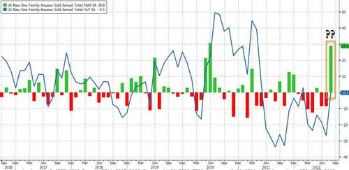
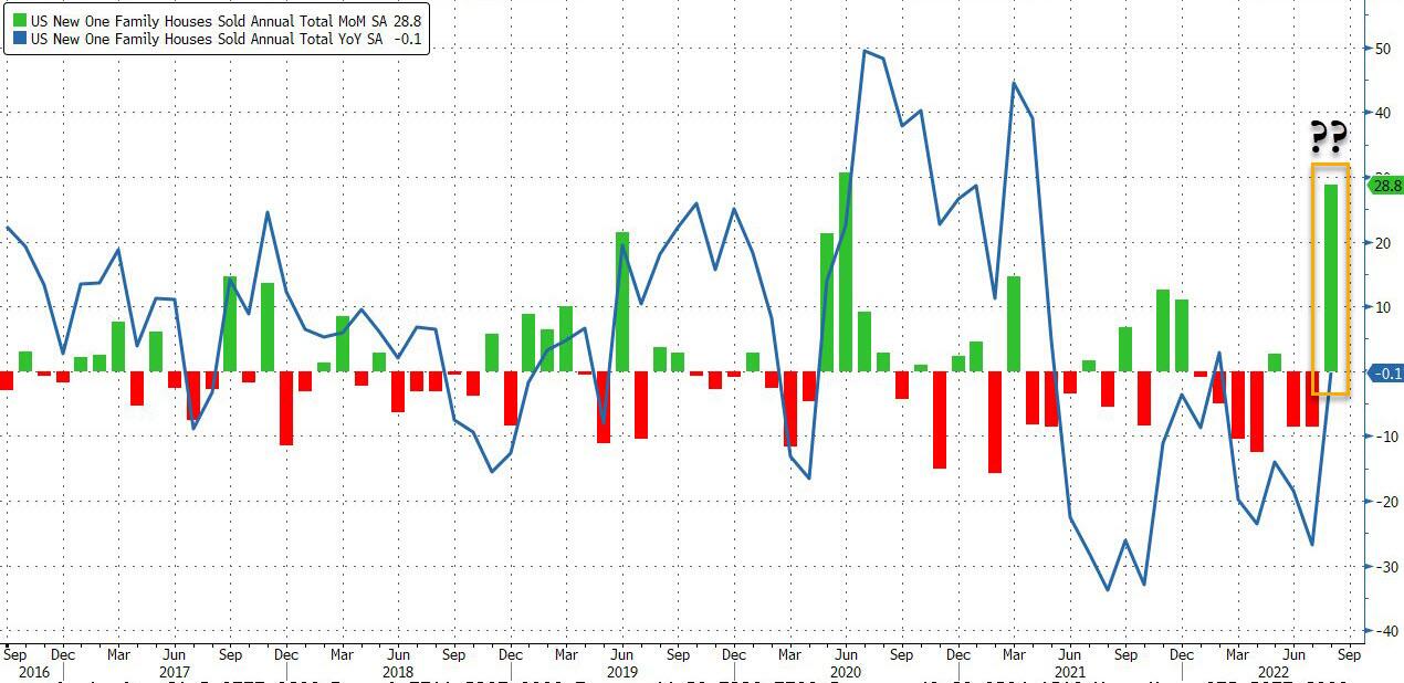
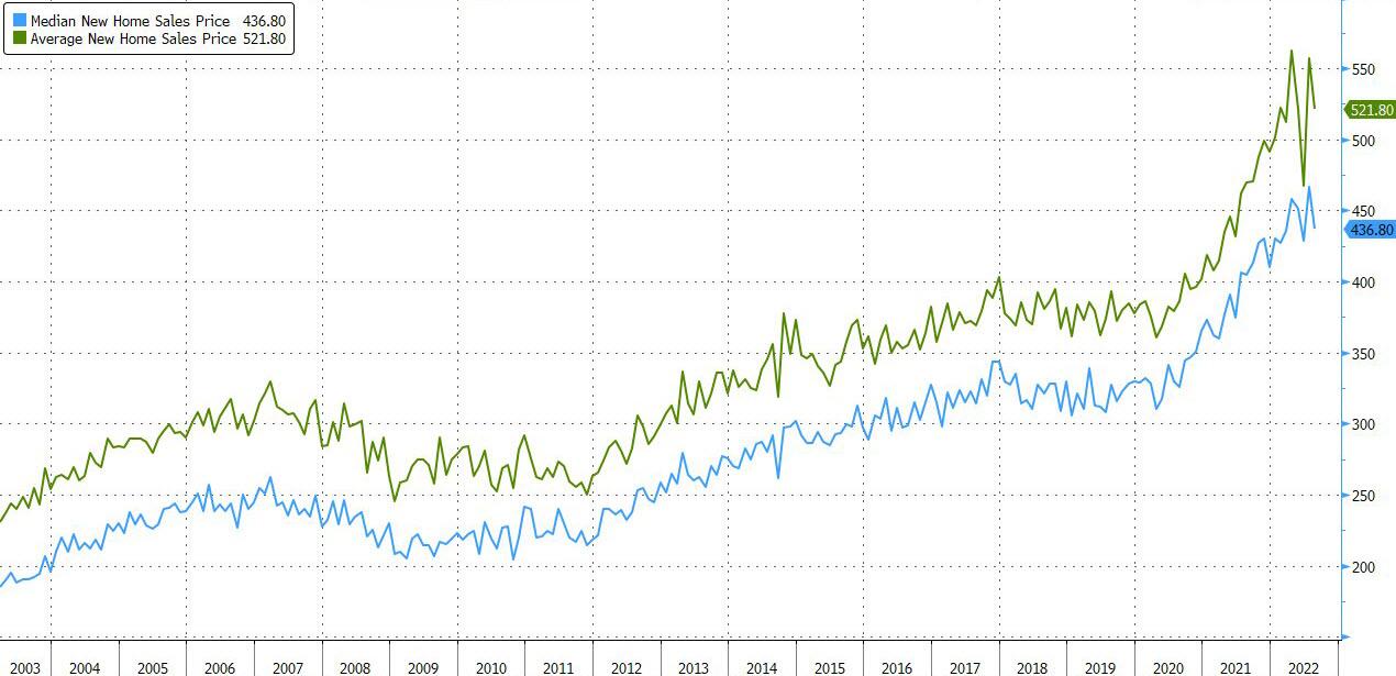
After last month’s jarring 12.6% tumble, which sent the SAAR to the lowest level since Jan 2016, US new home sales were expected to slide again if at a far more moderate pace: instead, we got another shocker because just minutes after Case-Shiller confirmed the first sequential drop in US home prices since 2012, the Census Bureau reported that in August, new homes unexpectedly soared by 28.8% – the 2nd biggest monthly increase on record (only behind the 30.6% spike in June 2020) smashing expectations of a -2.2% drop, and a massive reversal from last month’s upward revised -8.6% drop.
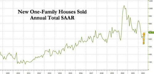
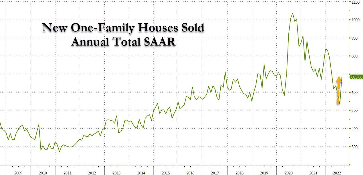
And so after 6 declines in the past 7 months, the actual SAAR number of new home sales exploded higher from 532K, the lowest in six years, to 685K, the highest since March!
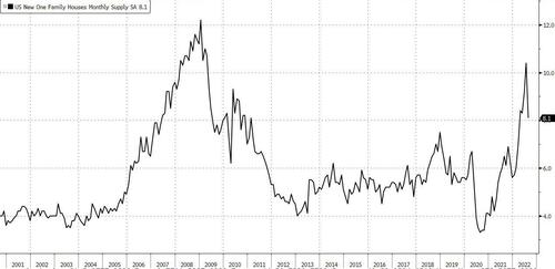
Thanks to the unexpected surge in sales, the supply of new homes – which last month hit the highest since 2009 – collapse by more than 2 months, to just 8.1 months of supply.
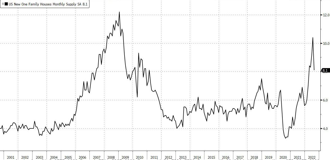
And as one would expect, the surge in sales took place as both Median and Average new home sales prices dipped, if just modestly.

After hitting a record high of $466,300 just last month, the median new home price slumped 6.3% to $436,800 which still is one of the highest prices on record.
While the surge in new home sales is likely a delayed aftereffect of yields which dropped in the late summer and have since exploded to the highest level in a decade – which likely assures that next month we may well see the biggest drop in new home sales on record – the Fed will not be happy to see this latest surge in new home sales which will be a sign that even more tightening is required.
https://www.zerohedge.com/energy/new-home-sales-unexpectedly-soar-second-biggest-increase-record